DATE OF WALKS: Tuesday 15 – Saturday 19 May 2018 (4 separate days walking)
DAY 1 – SKIDDAW via Little Man, 15 May
- START and END: Central Car Park, Keswick
- LENGTH: 11½ miles (4 hours 5 minutes plus lunch stop)
DAY 2 – NEWLANDS HORSESHOE, 16 May
- START and END: Car park below Catbells
- LENGTH: 12 miles (5 hours 10 minutes plus stops)
DAY 3 – BLENCATHRA via Halls Fell Ridge (up), Blease Fell (down), 17 May
- START and END: Car park near school, Threlkeld
- LENGTH: 8 miles (3 hours 45 minutes plus stops)
DAY 4 – SCAFELL PIKE via Mickledore (up), Corridor Route/Styhead Tarn/Great Gable (down), 19 May
- START and END: Wasdale Head car park
- LENGTH: 9 miles (4 hours 10 minutes plus snack/lunch/pub stops)
[LEJoG progress at start of this sidetrack: Day 16, Minehead]
Introduction
The ‘Sidetracks’ have thus far been marked by commemoration of my late grandmother. The Cleveland Way was undertaken in the wake of her funeral, and the Coast to Coast began after we visited her final resting place on her 85th birthday. In 2016 and 2017 we had stayed for a weekend in Windermere. In 2018 we visited Tarn Hows on 14 May again, but stayed for a week in Ambleside. This gave me a long-awaited opportunity to explore more of the Lake District, appetite obviously whetted by Helvellyn et al a year earlier. In advance of the holiday I bought all four of the OS Explorer maps and selected my four walks for the week.
Scafell Pike required a drive to the Western Lakes and a separate hotel booking, so that was saved for the weekend. Being very much a “save the best till last” kind of guy, Blencathra was too enticing to be tackled first – more importantly I needed to think for a couple of days about whether or not to try Sharp Edge as my first ascent. The Newlands Horseshoe involved six different peaks and I didn’t want to risk tiring myself out on day one, which meant the opener was…
SKIDDAW (931m)
The sixth-highest mountain in England, Skiddaw is (according to Wikipedia), “the simplest of the Lake District mountains of this height to ascend… and, as such, many walking guides recommend it to the occasional walker wishing to climb a mountain.” I will say that it was the right choice as my first Lake District fell outside the Coast to Coast. I will not say it was simple.
OK, well, it is to start with. From the car park at Keswick, the obvious path is marked on OS maps. Most of the first mile is on roads, taking you under an old rail bridge and around the leisure pool. Eventually you branch off onto a footpath which takes you over the A66 road before it starts to climb. Skiddaw is signposted from here (4 miles). Now called ‘Cumbria Way’ it skirts the hills of Latrigg (viewpoint detour optional) and Mallen Dodd, reaching a car park which you can use if you wish to cut your overall ascent by around a third.
It’s the next section, from c. 1000 feet to c. 2100 feet (per Wainwright’s guide), passing Lonscale Fell to the east, that I found tougher than expected, particularly as the sun came out for a while. It’s just a long, straight, steep climb with no peak in sight until you start on the winding (and slightly gentler) path up Jenkin Hill.

View of Keswick and Derwentwater from Jenkin Hill
(looking right back at the header photograph)
The peak which comes into view is, sadly, not Skiddaw proper but ‘Skiddaw Little Man’. As you scale Jenkin Hill you have the option of taking a half hour diversion to conquer Little Man. In doing so I think I made my first mental leap towards the aim of one day completing the 214 Wainwrights. Next birthday I asked for the seven-volume Pictorial Guide, so I’m committed now. Obviously it remains on the back burner while I continue with LEJoG. But this is just a brief illustration of how one walking bug can so easily beget another.
Coming down slightly from Little Man, the path to the summit of Skiddaw is now clear and not at all difficult. Here you will also meet what many walkers (including the man himself) regard as the best ascent of Skiddaw, from Bassenthwaite Village via Longside Edge. I have to confess it looked more dramatic than the Keswick route.
My 20 minute stay at the summit was characterised by rolling mist, which dissipated almost as suddenly as it arrived. What had been a warm if cloudy day turned very cold – over-dressing is advised when climbing to these heights. Can you expect crowds? Skiddaw on this mid-May morning was busier than Helvellyn last year, but not remotely comparable to Blencathra and (especially) Scafell Pike later in the week. I shared the summit with about a dozen other people and estimate there were around forty climbing at the same time as me.
The descent is easier on the knees than many in the Lakes, although care should be taken on Jenkin Hill and the path past Lonscale Fell. The endorphins and sense of satisfaction are worth every step.
NEWLANDS HORSESHOE
featuring, in order of appearance: Catbells (451m); Maiden Moor (575m); High Spy (653m); Dale Head (753m); Hindscarth (727m); Robinson (737m).
I hadn’t heard of the Newlands Horseshoe until a few weeks before the holiday. As an alternative to simply ‘bagging’ the more renowned peaks on my list, it appealed strongly. The way it turned out of course, the Horseshoe allowed me to bag six more Wainwrights anyway. I sold the first and smallest, Catbells, to my parents as a peak within reach of the casual walker. So it was that I had company for the start of the walk.
The car park near Gutherscale is quite difficult to find, and turns out to be a few unmarked spaces nestling under the foothills of Catbells. After a steady start, the casual walkers were unfortunately found out when the clear path disappeared and they had to clamber over some rocks. The summit of Catbells was still 15-20 minutes away, and the last few of those minutes would require some more precarious clambering. And so it was that, after only a quarter of an hour, they turned back and I no longer had company…
Catbells had been sold to me by a former work colleague as a small hill, so I admit to being surprised at the effort it took to reach the summit. My parents made the right decision to turn around. It isn’t hard as such, but nor should you just turn up and expect to vault up there in jeans and the shoes you wear to walk your dog or do the gardening. The shallow descent from Catbells is followed by a long pull up to Bull Crag and Maiden Moor. This is where you have to resist walking backwards, because the views from here over Derwentwater are a British natural wonder. Even people like me, with no interest in photography and only an iPhone to hand, can’t fail to capture some of the glory (the header image is from Bull Crag).
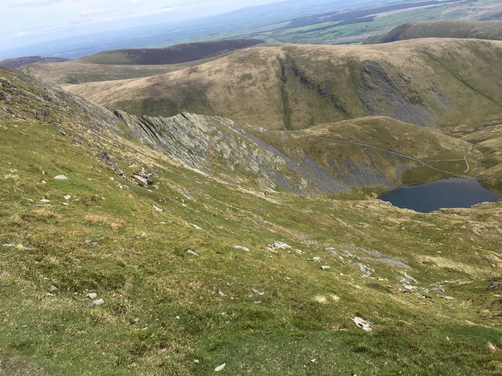
You then undertake a very gentle climb (a stroll, really) to High Spy, followed by a long and in places uneven descent to Dalehead Tarn. What faces you now will have been visible for some time already, but your mind (mine, at least) will have been trying to convince you there’s an easier way up. Nope. Dale Head looms in front of you, and the route takes you directly up from the tarn. It’s like Dollywaggon Pike from Grisedale Tarn, but steeper. Head down, grit teeth, stop as often as you like for water. It is the only really challenging part of the walk. You will be rewarded with this:

View of Newlands Valley from Dale Head (Skiddaw and Blencathra backdrop)
Hindscarth is next on the list. Make your way along the ridge (Hindscarth Edge) and you will see the climb to Robinson in front of you. However, if you want to make it six rather than five summits, take a diversion right (north) for Hindscarth itself. It’s well worth doing for the sake of a 20-minute round trip with no additional ascent. Indeed you can make your way back to the car park from Hindscarth if you so choose, leaving out Robinson altogether.
The OS map will tell you that doing both adds a considerable mileage. I and many others will also confirm that taking on Robinson single-handedly transforms this walk from pleasantly energetic into tiring. The ascent isn’t as steep as that to Dale Head, but it ranks second in effort as well as overall height. You clearly gain more metres from the car park to Catbells than you do from Hindscarth to Robinson, but Catbells was your first summit and Robinson is your sixth: QED. The real test comes with the descent: about half a mile after the summit you meet a precipitous drop, a broken path and some crags that appear to offer the only way down. A disclaimer here: I may have come off the Robinson plateau slightly west of the optimal route down to Stope Beck, and as a result others may have found this section easier than I did. But here (with photos) is an example of another walker who ended up, as I did, improvising his way down these crags on his butt.
It’s not over yet, for you need to be almost level in height with the beck when you come out of the valley, and if you’ve gone too far west, that means you’re on High Snab Bank and have to walk straight down a very steep hill. There are obvious steps cut out of the earth, but even so, your knees probably won’t thank you for such small mercies. Once you emerge on to the bridleways and farm roads, the hard part is most definitely over. Still more than two miles back to the car though.
A really wonderful spring walk, honestly. Perfect weather helped, no doubt: in less friendly conditions I might have been tempted to walk back down the valley from Hindscarth and save Robinson for another day.
BLENCATHRA (868m)
Blencathra, aka Saddleback, stands initimidatingly over the village of Threlkeld, just north of the A66 from Keswick to Penrith. A fair amount of my prep for today’s walk was spent researching its most intimidating feature: the narrow arête on the eastern ascent from Scales Farm, known as Sharp Edge. By reputation this is more nerve-racking and downright dangerous than Striding Edge on Helvellyn, due to the steep drop on both sides and especially because of the so-called ‘bad step’. People have been killed crossing this ridge, basically, and most fatalities or serious injuries are due to falls at this ‘bad step’. General advice seemed to be that taking on Sharp Edge (a Grade 1 scramble) as a first ascent of Blencathra, when not experienced in scrambling, was probably unwise in all but perfect conditions.
Well. Weather conditions were perfect. Dry, warm, barely any breeze. I approached from the west, close to Blease Farm, still undecided. My back-up would be Halls Fell Ridge, described by Wainwright as “positively the finest way to any mountain-top in the district” (his emphasis). I passed the start of the path to Halls Fell Ridge as if intending to tackle Sharp Edge instead… but if you’ve read the spoiler at the top of this page, there is no point trying to build tension here. Sharp Edge was too far away, I wanted to start climbing asap, and I thought I’d get a look at it from the summit and bookmark it for another time. Halls Fell Ridge it was, not without some regret.
It was barely after 9am and there were very few people on this route: I passed an older gentleman after 15 minutes of ascent, and a couple were just starting theirs below. The climb to the ridge itself is fairly tough, not far below the level of Dollywaggon Pike or Dale Head, but with better views than either. The ridge is less dramatic than Striding Edge, but no less daunting for someone who calls themselves a walker rather than a scrambler. I followed the crest as closely as possible for the first ¼ mile, but while traversing the rockface above a steeper drop on the western side, I lost my sunglasses and watched them tumble several hundred metres down the mountainside before coming to rest. At that point I left the crest, never to return, and made my way along the grass. Wainwright refers to a distinct path for walkers here, but I never quite found it, instead crossing scree and then having to walk almost vertically to the summit at Hallsfell Top. To be honest I was closer to the summit than I thought when leaving the crest, and it would have been quicker to stay there.

Halls Fell Ridge, from the summit of Blencathra (Threlkeld hidden)
It’s a glorious summit, I have to say. Above is the view back down Halls Fell Ridge; to the north-west you can see the Solway Firth and Scotland. And, take a short walk north and you can look down on Sharp Edge and Scales Tarn.
Sharp Edge (from sufficient distance not to look too scary) and Scales Tarn
A good dozen or so people emerged from their climb of Sharp Edge while I admired the views, and their courage. Groups of men my age and older were vocal and exhilarated. Younger men (climbing alone) were quieter, almost business-like. I didn’t see any women on the route.
Eventually I tore myself away and headed down via the longest but easiest of the suggested ascents, by Blease Fell. I wouldn’t choose to come up that way, given the alternatives, but it was a splendid walk all the same. A number of walkers were on their way up, some with dogs – it was that kind of route.
Blencathra is both a challenge and a grand half day out. I’d be all but certain to return, even if Sharp Edge didn’t need conquering.
SCAFELL PIKE (978m)
The family holiday ended on the morning of Friday 18 May, so I had already booked myself in for two nights at the Red Admiral, Seascale, as a base for Wasdale Head and England’s highest mountain. A long drive around the A595, good food and an early start on Saturday. As it turned out, the group on the table next to me for dinner were on the summit of Scafell Pike at the same time the following morning.
This was one of the greatest single day’s walking of my fledgling ‘career’. It had everything. I cannot imagine designing or scripting it any better. First, the weather was outstanding: a delightful spring morning with sunshine and just enough breeze. Perfect for walking. It’s a 20-30 minute drive from the Red Admiral, and as you approach Wasdale Head car park you realise that a) it’s the weekend and b) this is a much bigger attraction. For I was parked by 8:30am and the substantial car park (over 100 spaces) was more than half full already.
This was also royal wedding day, incidentally: Prince Harry and Meghan Markle were wed on the afternoon of Saturday 19 May. Apparently it was on telly and everything. As someone who regards the royal family with complete indifference, and those who queue up outside the Lindo Wing when there’s a royal baby on the way with total bewilderment, I can’t say I was upset to miss it. The knowledge that there was a competing national event also confirmed that the hundreds of people I saw on and around Scafell Pike today were my kind of people.
England’s highest mountain overlooks its deepest lake, Wast Water: the car park is at the northern head of the lake. Setting off on the eastbound path parallel with Lingmell Gill, the climb is gentle at first but soon becomes genuinely testing. I stopped a couple of times even before reaching the fork in the stream at Brown Tongue. From here the path to Hollow Stones becomes steeper – yes, steeper, although only for half a kilometre or so. Great views back down to Wast Water from here, as shown below:

At Hollow Stones, the so-called ‘easy’ route, used for the Three Peaks Challenge because of its swifter ascent, proceeds east to Lingmell Col before a steeper but relatively short SE-bound path to the summit. I had chosen to veer right here and approach via Mickeldore, a ridge between England’s two highest mountains. Part of the reason was to get a good look at Sca Fell (England’s no.2) and the seriously tough ascents via Broad Stand (strictly for rock climbers only) and Lord’s Rake/West Wall (not recommended due to rock falls). The path to Mickeldore col feels harder than it looks. My mind was distracted from the climb by a man who was calling for a lost sheepdog – I do hope they were reunited.
Mickeldore itself is an enjoyable little scramble through a crevice vaguely reminiscent of this (purely in size relative to a human, I hasten to add, not in smell, or indeed length). Emerging on to the ridge, you head NE over a boulder-strewn landscape. The path can be indistinct, but the summit is soon visible in good weather and you can follow your nose easily enough. This does not mean you can leave your compass at home: my conditions were perfect, yours may not be.
The summit is quite expansive: there’s a cairn which I used as my WordPress profile picture, as well as a more obvious and popular elevated platform, photographed below:

There’s also plenty of room to sit down and admire the views, eat or drink. I spent 45 minutes there and must have shared it with around fifty people in that time. Many more than that, including a Three Peaks team of around two dozen, were within a few minutes of the summit by the time I left, at around 11:15. On the way down to join the Corridor Route, a number of walkers separately asked me how far it was to the summit. I think this was the first day when I began to feel like a seasoned hill walker rather than a novice.
The Corridor Route (as far as Sty Head) was possibly the highlight of the day, even above reaching the summit itself. With the Toblerone shape of Great Gable a constant companion to your left, wind your way downhill over stony paths, fords, Greta Gill, Piers Gill and some occasional narrow and exposed rock formations (including one section where I had to queue and wait for a group to cross from the other end), before finally reaching a perfect lunch spot near Styhead Tarn. It’s just difficult enough to generate a satisfied smile, but just easy enough to make for a pleasant afternoon.

View of Scafell Pike from Styhead Tarn, looking ahead to the Corridor Route
From here I returned to the major walkers’ junction at Sty Head, choosing the western path below the summit of Great Gable. Note that this is not at all a steep descent, but it is rough underfoot and care should be taken on steps and stones. Lingmell Beck is below you to the left. Eventually the path reaches the beck and joins Moses Trod, a well-used route from Honister to Wasdale Head over Great Gable. Now the only major obstacle between yourself and the conclusion is this. Very busy it was too, when I popped in for half a Hobgoblin Gold. I felt I’d earned more than a half, but that was as much of a treat as I could allow myself when driving back within the hour.
There’s a brief road section after the pub, then a half mile footpath through reeds and bushes brings you out at Wasdale Head car park.
I appreciate that you may not be as blessed with the weather if you plan the walk on a particular day. But really, Scafell Pike is glorious. I don’t think I fully appreciated the magnificence of its surroundings until I was there – beforehand, I was ignorant enough to think it was just “England’s highest mountain”, needed bagging for that reason alone, and its appeal was limited beyond that. You can’t go wrong whichever ascent and descent you choose, but I would strongly recommend working the Corridor Route in somehow.
More Lake District Classics to come in 2019, when the family returns to Ambleside and Tarn Hows for the week of my grandmother’s 87th birthday.
Picture (16 May) combines three of these four: taken during the Newlands Horseshoe walk, it shows Catbells (centre), from Bull Crag, with Skiddaw (centre/left) and Blencathra (right) dominating the landscape in the distance, across Derwentwater.