Welcome to LEJoG Day 54, unless you’re a barbarian (in which case keep out!)
Day 54 pre-amble
Today’s post title is inspired by the lyrics to this song from 1982. Here’s the key refrain:
You keep me running round
Well that’s alright with me
Up and down, I’m up the wall
I’m up the bloody tree
There’s a slight alteration to reflect the fact I didn’t go ape, but ploughed through several forested areas which caused one or two swears (some stronger than ‘bloody’!) due to the boggy ground.
The dominant feature of today’s walk was always going to be Hadrian’s Wall. For around 9 miles after Greenhead, the Pennine Way route coincides with the best-preserved section of the 2nd-century Roman emperor’s defence against those troublesome Scottish barbarians. It’s the Way’s main attraction north of Alston, at least when you’re consulting guidebooks and route maps. Did it live up to expectations? Read on…
LEJoG Day 54 (Tuesday 20 August 2019)
Greenhead to Bellingham (22½ miles)
Cumulative: 767½ miles
Facts: Time on walk: 7 hours 30 minutes. Average speed: 3.00 mph. Weather: Overcast; drizzle at start and intermittently until early afternoon. Later cloudy with some sun; warmer.
Practicalities: The walk began as soon as I left Holmhead. This was my longest day on the Pennine Way, and the longest on LEJoG since Day 15, so I took up their offer of a packed lunch.
The walk
Start: Holmhead Guest House, near Greenhead, 9:45am. End: Pennine Way sign after North Tyne bridge crossing, near Bellingham, 6:15pm.
“Up and Down, I’m Up The Wall”
There’s no subtle, teasing build-up. Almost as soon as you leave Holmhead, you are confronted with a huge Roman defensive ditch, running parallel with the first hill climb. Below is a retrospective from the top of the hill:
 Defensive ditch (Holmhead at bottom of hill and around a few corners)
Continuing alongside the ditch, you come to a road and car park which mark the approach to Walltown. This bench confirms it:

Evidently… (Warning: link contains lots of ‘bloody’ and some swears much stronger)
First there’s a short climb to Walltown Quarry, and after a brief ridge you come to Walltown Crags. Here you could be back on the South West Coast Path, or in the mountains of the Dales or Peaks. It’s the first of many moments which justify the “Up and Down” of the title. Below is a typical view, from just after Milecastle 45A – the milecastles are numbered east to west, incidentally. To scale the hill in the foreground you first have to descend to a road and climb over a ladder stile. To reach the second hill (an even sharper climb) you have to descend again. Trailblazer states that the Hadrian’s Wall section “rather specialises [in] short, sharp gradients”. They’re right, as usual.

The hills after Walltown Crags
I should mention that, between those two hills, you will find Turret 44B or King Arthur’s Turret.
To be honest this felt more like a regular hill walk than an exploration of an ancient monument, and this surprised me somewhat. You are not always close to the Wall. Although it would be fair to add that my experience, and therefore my memories, are dictated by the need to complete 22½ miles in the day. I would like to have dwelt on some of the milecastles and turrets, but always resisted due to the thought of the long miles ahead. If you are walking the Pennine Way and want to make the most of what may be your only visit to Hadrian’s Wall, you may prefer to split this day into two at, say, Once Brewed. There are plenty of Pennine Way bloggers who have done just that.
There follows a long, shallow descent to a couple of farms – Cockmount and Great Chesters. The latter is notable for its proximity to Great Chesters Fort. Most of the 2-3 miles between the descent from Walltown Crags and Caw Gap is on fairly level ground, with a post-Roman stone wall for company. Traces of the original Wall lie underneath, but unless you divert to Great Chesters Fort or explore the Vallum to the south, there’s little to inspire on this middle section. Not that it’s without merit – for example, just after the road at Burnhead, there’s an attractive lake in a flooded quarry:

Around Cawfield Crags, lying between Milecastle 42 and Turret 41A (Caw Gap), there’s a long section of original Wall. I didn’t make the most of it though, following what seemed to be the obvious path, but one that turned out to be a hundred metres or so south of the stile at Caw Gap.
Caw Gap has been mentioned in passing three times already. This place sticks in the mind because it marked the start of the hardest piece of concentrated ascending and descending since the halcyon days of the South West Coast Path. From here to Winshields Crag, the ups and downs are relentless. None are particularly sustained or even especially steep, but I promise you will really feel it. There are more of them than the Trailblazer map shows, as well.
Winshields Crag, at 345m, is the highest point on Hadrian’s Wall and therefore an obvious place to stop for lunch. Not my packed lunch, yet. On such a long day I was determined to wait until I was over halfway before eating that. Just a Grenade protein bar.

Trig point at Winshields Crag (highest point on Hadrian’s Wall)
At the bottom of the next hill is Steel Rigg Car Park, probably the busiest of the day for visitors. Immediately after that is Peel Crags, perhaps the steepest and most visually striking ascent of the day. This combination of increased human activity and a naturally dramatic backdrop gave Peel Crags the nod when it came to selecting today’s header image.
There are several more ups and downs between Peel Crags and the ridge overlooking the lake at Crag Lough. Amongst them I somehow missed the lone sycamore which featured in laughable geographical liberty-taker movie Robin Hood: Prince of Thieves. The last long climb comes shortly afterwards, at the splendidly-named Hotbank Crags. This may have been the toughest of all actually, probably because of the energy sapped earlier and not yet replaced.
Tiredness really creeps up on the walker today. According to Trailblazer this stage has only slightly less total ascent than the jaunt over Cross Fell. Winshields Crag is only just over a third of the height of Cross Fell, and by the time you reach the latter you’ve already conquered Knock Fell and Great Dun Fell and been in the mountains for the best part of three hours. Hadrian’s Wall is much more insidious a challenge. But a challenge it most definitely is. Do not underestimate how much effort you will expend.
If I were planning this walk again, I would definitely stay overnight at Once Brewed. But in this particular week, there was a choice of which long day to split: the 22 miles from Greenhead to Bellingham, or the 26 from Byrness to Kirk Yetholm, In isolation that’s an easy decision for me: 26 miles over the Cheviot Hills in a day is a ridiculous notion. But in the round, it would be worth taking 19 days instead of 18 to complete the Pennine Way. And if 18 days was all I had, then the better choice is to walk from Haworth to Malham in one go. The last six miles from Gargrave are possibly the easiest of the entire Pennine Way.
So, shortly after Hotbank Crags, you reach the unprepossessing Rapishaw Gap and finally leave Hadrian’s Wall behind. At this point I recommend the wonderful paragraph at the bottom of the ‘Hadrian’s Wall’ inset on page 234 of the 5th edition of the Trailblazer guide to the Pennine Way (link to the book here). No spoilers: it’s perfect and profound, and anything I could say here would be facile by comparison. So have a photo instead:

Leaving Hadrian’s Wall at Rapishaw Gap: over that stile and head north…
(And Through the Bloody Trees)
And, apologies to any religious readers of 50FootHead, but oh God… I don’t even think Hadrian’s Wall was all that, certainly not compared to Malham to Horton, but set against what followed… well, can someone get nostalgic within an hour? The words per mile count is going to plummet here, I can tell you.
First is a walk across featureless moorland, with only Wark Forest in the middle distance to provide any psychological incentive. After a mile or so, I was catching up with another male walker, and we were heading towards some cows. One of them, separate from the herd, took a mild interest in the other guy but he passed by without incident.
Now, since the Friesian Standoff, I’d walked through several cow fields with nothing more than a few hard stares from our bovine friends, and just the one brief delay near a footbridge on Day 44. Such was their lack of bother, I’d almost begun to think I was some kind of cow whisperer in training. This illusion was shattered right here. If the cow had been mildly curious as the first walker passed, he was positively frisky as I approached. And as I drew level, about 15 yards away, he kicked his legs and started to run as if he was going to charge straight for me. I shouted “Oh fuck no!” and ran forward myself… to my surprise and relief the cow retreated immediately. And that was that, thankfully.
Overtook the other walker and joined the track leading into Wark Forest. At the end of the track I stopped to eat my packed lunch at 2:10pm. Half an hour later I returned to the Pennine Way, heading through those bloody trees. Completely protected from the sunshine that had now broken out, the ground was marshy throughout and very boggy in places. Not quite as demoralising as yesterday’s trudge through Black Hill, but pretty dismal and made worse by the warm temperatures and resulting muggy atmosphere.
There are about 10 miles between Rapishaw Gap and the delightfully named Shitlington Crag, it’s largely dull and there are boggy areas spread throughout the journey, particularly where you pass through forest. I’ll be honest: if I wasn’t listening to Chart Music, or if I’d not packed more carefully to ensure I carried only my 30-litre pack, or if it had rained, I would have HATED that 10 miles.
After Wark Forest came Haughton Common. Open land with marshy areas; little to recommend it. Then another forested section, crossing several east-west tracks. Plenty of bog here. A very brief section of isolated road (still long enough for a car to pass me), then a good track, dry underfoot, heralding one of the easiest parts of the afternoon.
Eventually this leads to a very fertile area of land where you wade knee deep through plants on the way down to Warks Burn, then climb steeply out on the other side. At Horneystead Farm there was a sign indicating refreshment for walkers, but I couldn’t see any food or drink and didn’t want to spend time looking. Across the road and past Leadgate Cottage there was a sign saying that Bellingham was still 5¼ miles away, meaning that yet again the guidebook seemed to be underestimating the length of the stage. Not great for morale.
Passed another house at Low Stead and joined a tarmac road heading NE, then a track heading downhill to Houxty Burn. Made exactly the same navigational error as Dave here, but it was only 200m to the bridge I should have crossed. Next up: the climb to Shitlington Crag.

Shitlington stopgigglingokitsjustmethen Crag
Quite unkind after 19 miles, and the first proper ascent for about 10 miles. The killer is actually the bit between the crag and the path that takes you past the relay station overlooking the crag. The sort of hill that, if it came in the first hour of a walk, you’d barely remember, but when you’re nearly 7 hours in and want your home comforts, feels never ending.
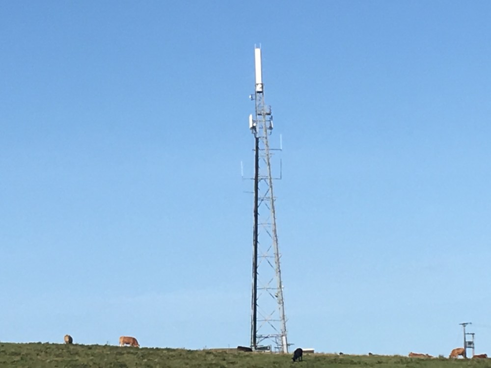
The relay station
Not much to report afterwards. After descending on the far side of the crag, Bellingham (the g is pronounced as a j) comes into view. There’s an overgrown and convoluted little path running beside the B6320, and then you join the road itself. This final section drags, man. My hotel was 5-10 minutes walk before the village of Bellingham itself: even so it seemed to take an age to reach the North Tyne river, where the Pennine Way leaves the road.
I say again: this is a long and often tedious day. Be kind to yourself and split it.
After the walk
Checked in at the Riverdale Hall Hotel. Compared to most of my chosen accommodation on the Pennine Way, this could be described as “opulent”. It’s certainly much closer in appearance and ambience to the kind of hotels I’ve stayed in on business, although considerably cheaper. Most walkers stay in B&Bs in Bellingham itself, but none of these came up during my search on booking.com or Trip Advisor, and I really couldn’t be bothered phoning them separately.
That said, the rooms feel somewhat dated and only one small biscuit was provided with the tea. The best part of the stay was the restaurant: gleaming cutlery, pristine white tablecloths, great menu, reasonably priced and suitably refreshing after a very long walk. Otherwise the usual quiet evening making notes and reading ahead about tomorrow’s journey to Byrness.
Postscript – My Listening Pleasure
Nothing during the Hadrian’s Wall section. Then, second listen to the latest Chart Music (#42) taking me from Rapishaw Gap to the Shitlington Crag climb. The second Critics’ Choice podcast and another excellent serving. I might tentatively suggest that, when there’s only one podcast per month now, two from 1976 and two from 1981 (plus one from Xmas 1980) since last Christmas feels uncharacteristically restrictive, but the content was as fantastic as ever.
Picture (taken 20 August 2019) shows Peel Crags, just after Steel Rigg Car Park, around 7½ miles into today’s walk.
Next: Day 55 (21 August 2019)… in which there’s no Wall, but many more trees.